Monday, 27 February 2017

Young Nature Reserve

Location, access and how to get there

Young Nature Reserve is located 15 kilometers southeast of Young, around 145 kilometers from Canberra GPO (2 hours drive). The Reserve is surrounded by private land and is not open for public use.

http://maps.six.nsw.gov.au/

Bushwalking opportunities

Given the small size and limited features of the Reserve there seems little to attract bushwalkers, even if access was allowed.

Camping and other facilities

Obviously, camping is not allowed and there are no visitor facilities.

Features

Size
453 hectares.
Natural features
The Reserve has some significant remnant vegetation.
Heritage features
None known.

References

Young Nature Reserve Statement of Management Intent (2014) - link
National Parks and Wildlife Service - Young Nature Reserve website - link


Sunday, 26 February 2017

Jindalee National Park

Location, access and how to get there

Jindalee National Park is located 10 kilometers north of Cootamundra. It comprises two separate parts on each side of Berthong Road. At its nearest accessible point it is around 155 kilometers from Canberra GPO (1 hour 50 minutes drive). Access to the Reserve is via Berthong Road or Burley Griffin Way. Information on the Park is scant since a Plan of Management has yet to be published.

http://maps.six.nsw.gov.au/

Bushwalking opportunities

Walking is allowed in the Park, but there is little of interest apart from the forest itself. There are only a few kilometers of management trail within the Park, and no walking tracks are known.

Camping and other facilities

No information on camping or other facilities has been found. Check with the National Parks and Wildlife Service Tumut office (02 6947 7000).

Features

Size
1,076 hectares.
Natural features
Jindalee National Park is relatively small and with no real features apart from the forest. There are no high peaks or gullies, although a number of small watercourses run out of the Park on all sides.
Heritage features
No information is available.

References

Jindalee National Park Statement of Management Intent (2014) - link
National Parks and Wildlife Service - Jindalee National Park website - link


Saturday, 25 February 2017

Ulandra Nature Reserve

Location, access and how to get there

Ulandra Nature Reserve is located 25 kilometers southwest of Cootamundra, near the village of Bethungra. It is around 190 kilometers from Canberra GPO (2 hours 20 minutes drive). Access to the Reserve is via Mahomets Road from Bethungra. The alternative road that enters the Reserve from the southwest (off Bethungra Road) is a private road with a locked gate. Similarly, fire trails entering the Reserve at various points are through private property and not accessible to the public.

http://maps.six.nsw.gov.au/

Bushwalking opportunities

Walking is allowed in the Reserve "for the appreciation and enjoyment of its wildlife and natural environments". There are no walking tracks, but there are around 30 kilometers of management trails within the Reserve boundaries. A three kilometer private road links the Reserve's southwestern boundary to the summit of Mount Ulandra. A walk from Mahomets Road entry to Mount Ulandra along management trails and the summit road is about 20 kilometers return.

Camping and other facilities

The now rather dated (1994) Plan of Management for the Reserve does not indicate whether camping is allowed, although it would generally be expected that it is not. Check first with the National Parks and Wildlife Service Tumut office (02 6947 7025). Fires are definitely not allowed. There are no public use facilities within the Reserve.

Features

Size
3,934 hectares.
Natural features
The Reserve is dominated by Mount Ulandra (761 meters), which is 450 meters above the surrounding country. A television transmission tower is on the summit of the mountain. The terrain within the Reserve is "a series of ridges, hills and valleys running roughly north-south". A number of creeks flow out of the Reserve. The Reserve is open forest, and was established to protect stands of Cootamundra wattle.
Heritage features
A number of Aboriginal heritage sites have been identified in the Reserve. Remains of past grazing, agriculture and forestry use of the Reserve may also be seen.

References

Ulandra Nature Reserve Plan of Management (1994) - link
National Parks and Wildlife Service - Ulandra Nature Reserve website - link
Wikipedia - link


Thursday, 23 February 2017

Ellerslie Nature Reserve

Location, access and how to get there

Ellerslie Nature Reserve is located 17 kilometers northwest of Adelong, around 200 kilometers from Canberra GPO (2 hours drive away) via the Hume and Snowy Mountains Highways. Public walking access to the Reserve is from the Snowy Mountains Highway about 9.5 kilometers south the Hume Highway, where there are a limited number of parking spaces.

http://maps.six.nsw.gov.au/

Bushwalking opportunities

Day walking is allowed in the Reserve. There are no walking tracks in the Reserve, but there are around 45 kilometers of management trails within or adjacent to the Reserve boundaries, mostly following ridges.

Camping and other facilities

Camping and solid fuel fires are not allowed. There are no public use facilities within the Reserve.

Features

Size
1,877 hectares.
Natural features
There are no distinctive peaks in the Reserve, which is characterised by steep creek gullies and ridges above these. Blanch Creek and Jimmys Creek are the main watercourses flowing through the Reserve. Six distinct forest ecosystems and eight threatened fauna species have been identified within the Reserve.
Heritage features
Survey work has identified a number of Aboriginal heritage sites, but further sites may still be discovered. Some historical sites have also been identified.

References

Ellerslie Nature Reserve Plan of Management (2010) - link
National Parks and Wildlife Service - Ellerslie Nature Reserve website - link


Tumblong State Conservation Area

Location, access and how to get there

Tumblong State Conservation Area (SCA) is located 30 kilometers northwest of Tumut, around 180 kilometers from Canberra GPO (2 hours drive away). There is no public vehicular access to the Park and it can only be accessed by walking through private property, for which landowner permission is required.

http://maps.six.nsw.gov.au/

Bushwalking opportunities

Day walking is allowed, but note access issues.

Camping and other facilities

Camping and solid fuel fires are not allowed. There are no public use facilities within the SCA.

Features

Size
746 hectares.
Natural features
There are no distinct peaks in the SCA, which is located on the northeastern side of a ridge. Altitude range within the SCA is from 300-588 meters. Six distinct forest ecosystems have been identified within the SCA.
Heritage features
Survey work has identified one Aboriginal heritage site, but further sites may still be discovered. There are no significant historical sites in the SCA.

References

Tumblong State Conservation Area Plan of Management (2008) - link
National Parks and Wildlife Service - Tumblong State Conservation Area website - link


Sunday, 19 February 2017

Minjary National Park

Location, access and how to get there

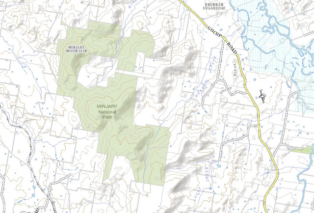
Minjary National Park is located 10 kilometers northwest of Tumut, around 185 kilometers (a 2 hour 10 minute drive) from Canberra GPO via Hume Highway and Gocup Road. The park is accessed via McGrath Trail (possibly also known as Burnie Trail) which runs off Gocup Road to the right about 25 kilometers south of Gundagai and enters the Park from the north. There is a gate where McGrath Trail enters the Park, and since there is no public vehicular access within Minjary, cars should be parked at the gate.

http://maps.six.nsw.gov.au/

Bushwalking opportunities

Walking is allowed in the Park and there are about 18 kilometers of management trails within the Park boundary, including one to the summit of Minjary Mountain, which the NSW National Parks and Wildlife Service tells me  is worth a visit although views are limited by the vegetation. About one kilometer southwest of the Minjary Mountain trig, a little to the right of Minjary Trail, however, there is an old hang gliding ramp and there are excellent views from that area to the west. National Parks and Wildlife warn, however, that the ramp itself should not be stepped on due to its dilapidated state and the risk of falling through.

Camping and other facilities

Bush camping is permitted in the Park.

Features

Size
1,462 hectares.
Natural features
The highest peak is Minjary Mountain at 763 meters. Seven forest ecosystems have been identified within the Park which is part of the Murrumbidgee River catchment. Seven threatened species of fauna have been identified.
Heritage features
There are some Aboriginal heritage sites within the Park, and historical sites relating to the Park's former status as a State Forest.

References

Minjary National Park Plan of Management (2004) - link
National Parks and Wildlife Service - Minjary National Park website - link


Mudjarn Nature Reserve

Location, access and how to get there

The Mudjarn Nature Reserve is located 15 kilometers north of Tumut off Brungle Road, about 180 kilometers from Canberra GPO (2 hours drive). There is no public vehicular access to the Reserve. Pedestrian access is complicated. The NSW National Parks and Wildlife Service tells me that there are Crown road easements going into the Reserve off public roads (presumably Brungle Road), but no track exists along these easements. The easements can be located on the relevant parish map, but then they would then have to be located "on the ground". They advise seeking landholder permission prior to attempting to access the Reserve.
Note that the 2008 Plan of Management for Mudjarn noted plans to work with Tumut Council to provide car parking and pedestrian access from Brungle Road, but this has not happened yet.

http://maps.six.nsw.gov.au/

Bushwalking opportunities

Walking is permitted in the Reserve, but note access issues above. There are no walking tracks and only one management trail along the eastern side of the Reserve. The NSW National Parks and Wildlife Service tells me that walking in the Reserve is difficult due to the density of the callitris pines.

Camping and other facilities

The Reserve Plan of Management notes that it is used for camping, but makes no mention of whether this should be allowed. There are no visitor facilities in the Reserve. 

Features

Size
591 hectares.
Natural features
The highest peak is Pine Mountain Peak at 691 meters. A number of small creeks drain out of the Reserve. It has a heavy cover of callitris pine and kurrajong that give it a distinctive dark appearance.
Heritage features
There are a number of recorded Aboriginal heritage sites and a number of historical sites including mine sites and old post and rail fences.

References

Mudjarn Nature Reserve Plan of Management (2008) - link
National Parks and Wildlife Service - Mudjarn Nature Reserve website - link


Saturday, 18 February 2017

Oak Creek Nature Reserve

Location, access and how to get there

The Oak Creek Reserve is located north of the village of Wee Jasper on the eastern side of the Goodradigbee River. There are no roads or trails that provide public vehicular access to the Reserve. Walking into the Reserve from Wee Jasper Road would involve crossing private property and should only be undertaken with the landowner's permission. The nearest private road access point to the Reserve is off the Wee Jasper Road about 78 kilometers from Canberra GPO (1 hour 15 minutes drive). Some visitors have accessed the Reserve from the Goodradigbee River side, but this would require a kayak or similar and is apparently quite tricky to clamber out when water levels in Lake Burrinjuck are low.

http://maps.six.nsw.gov.au/

Bushwalking opportunities

Day walking is permitted in the Reserve, although note access issues. Overall, walking here is probably not worth the effort for the average bushwalker, and is not encouraged by the National parks and Wildlife Service in any case.

Camping and other facilities

Camping and fires are not permitted in the Reserve.

Features

Size
404 hectares.
Natural features
The Reserve is divided into two sections by Sugarloaf Creek. The highest peak is in the far south of the Reserve and is a little under 550 meters elevation. There are five forest ecosystems within the Reserve.
Heritage features
No Aboriginal heritage sites or historical sites have been identified.

References

Oak Creek Nature Reserve Plan of Management (2010) - link
National Parks and Wildlife Service - Oak Creek Nature Reserve website - link
Wikipedia - link


Burrinjuck Nature Reserve

Location, access and how to get there

The Burrinjuck Nature Reserve is located on the northern end of Lake Burrinjuck. It can only be accessed by car from Burrinjuck Road, which enters the Reserve about 104 kilometers (1 hour 15 minutes drive) from Canberra GPO. Around 2.2 kilometers into the Reserve, two management trails intersect with Burrinjuck Road, the Childowla Trail to the west and the Link Trail to the east, but private vehicles are not permitted on management trails within the Reserve. Burrinjuck Waters State Park, about 6.2 kilometers into the Reserve along Burrinjuck Road, has a range of visitor facilities and a single walking trail north into the Reserve.

http://maps.six.nsw.gov.au/

Bushwalking opportunities

Walking is permitted in the Reserve and there are two specific walking tracks: a section of the Hume and Hovell Walking Track which passes through the Reserve east of Burrinjuck Road and then into the Burrinjuck Waters State Park, and a very steep hiking trail from the State Park to Mount Barren Jack. There is also a network of about 30 kilometers of management trails in the Reserve west of Burrinjuck Road that could be walked. 

Camping and other facilities

Camping and fires are not permitted in the Reserve. There are, however, camping and other facilities in the adjacent Burrinjuck Waters State Park.

Features

Size
5,207 hectares.
Natural features
The highest peak is Mount Barren Jack at 966 meters, and there are two other significant peaks in the Reserve: Mount Little Jack (883 meters) and Mount Europe (843 meters). Barren Jack Creek flows through much of the Reserve before flowing into Lake Burrinjuck. Other creeks flow out of the Reserve to the north, east and west. There are six forest ecosystems within the Reserve and sixteen Threatened species of fauna.
Heritage features
There are seven recorded Aboriginal heritage sites in the Reserve, and more are believed to exist. There are also fourteen identified historical sites.

References

Burrinjuck Nature Reserve Plan of Management (2010) - link
National Parks and Wildlife Service - Burrinjuck Nature Reserve website - link
Wikipedia - link
Burrinjuck Waters State Park website - link


Wednesday, 15 February 2017

Wee Jasper Nature Reserve

Location, access and how to get there

The Wee Jasper Nature Reserve is located immediately west of the village of Wee Jasper, about 85 kilometers (1 hour 20 minutes drive) from Canberra GPO via Mountain Creek and Wee Jasper Roads. The Reserve is best accessed via a section of the Hume and Hovell Walking Track which has one entry point on the Wee Jasper Road about 275 meters south of the Caves Road intersection, and a second entry point, also on the Wee Jasper Road, about 6.5 kilometers from the Caves Road intersection. A road called Native Dog Trail (off Wee Jasper Road 1 kilometer south of the Caves Road intersection) also passes through the Reserve, but is not open to the public.

http://maps.six.nsw.gov.au/

Bushwalking opportunities

Walking is permitted in the Reserve. A 3.5 kilometer section of the Hume and Hovell Walking Track passes through the southern part of the Reserve . Other parts of the Reserve can be accessed from this track.

Camping and other facilities

Camping is not permitted, although there are numerous campsites in the Wee Jasper area. There are no visitor facilities in the Reserve.

Features

Size
632 hectares.
Natural features
The highest points in the Reserve are along its western border, with some points on the ridge above 800 meters elevation. The ridge should generally provide views to both the east and west. Native Dog Creek flows into the Goodradigbee Valley through the far north of the Reserve, and there are a number of creeks further south that also flow into the Valley. Church Cave is located in the Reserve, but National Parks and Wildlife Service warns that it contains fungus spores that can cause Histoplasmosis, has a threatened bat colony and can only be entered by permit. There are four distinct forest ecosystems within the Reserve and six vulnerable species of fauna.
Heritage features
No Aboriginal heritage or historical sites have been identified in the Reserve.

References

Wee Jasper Nature Reserve Plan of Management (2010) - link
National Parks and Wildlife Service - Wee Jasper Nature Reserve website - link
Wikipedia - link


Tuesday, 14 February 2017

Black Andrew Nature Reserve

Location, access and how to get there

The Black Andrew Nature Reserve is located immediately south of Burrinjuck Dam and is 10 kilometers northwest of Wee Jasper. Trails enter the Reserve on the west, south and east sides, but all pass through private land and require landowner permission to use. Private vehicles are not permitted on management trails within the Reserve. The nearest points of vehicular access are about 100 kilometers or a two-hour drive from Canberra GPO via Mountain Creek Road and Wee Jasper.

http://maps.six.nsw.gov.au/

Bushwalking opportunities

Walking is permitted in the Reserve, though no facilities have been or seem likely to be put in place to encourage it. There are no formed walking tracks, and as noted above, access is problematic. Three management trails run through the Reserve, but they do not interconnect within the Reserve boundary and their total combined length within the Reserve is only around 12-13 kilometers.

Camping and other facilities

Camping and solid fuel fires are not permitted, and there are no visitor facilities in the Reserve.

Features

Size
1559 hectares.
Natural features
The highest peak is Black Andrew Mountain at 935 meters. MacPhersons Swamp Creek and its tributaries flow through the Reserve. There are seven distinct forest ecosystems within the Reserve and surveys undertaken in 2004 found six vulnerable species of fauna.
Heritage features
There are a number of Aboriginal heritage sites in the Reserve and an abandoned mine in the southwest.

References

Black Andrew Nature Reserve Plan of Management (2006) - link
National Parks and Wildlife Service - Black Andrew Nature Reserve website - link
Wikipedia - link